Showing posts with label Historic Trails. Show all posts

Saturday, July 7, 2018

The Great River Road


During our visit to the Mississippi River Museum in Memphis, Tim and I just happened to pick up a map of The Great River Road, a National Scenic Byway that runs parallel on both sides of the Mississippi River all the way from its headwaters in Minnesota to its mouth at the Gulf of Mexico.  Since we are headed north to Minneapolis for a vacation with our children in mid-July, I decided we should forsake the interstates and travel the back roads there instead.  Low and behold, Tim agreed!


Green paddlewheel highway markers tell you that you're on the right track, but I also went online to The Great River Road web site.  There I discovered possible itineraries and information about roadside attractions that helped me plan our trip.  Being a Kansas farm girl, I'm always intrigued by places that promote agriculture so I found the section on Agritourism most helpful.  There you select a category you wish to visit such as B & Bs, cheese factories, pick-your-own orchards, farm petting zoos or wineries.  Of course, the page also lists museums and interpretive centers as well.

I also downloaded The Great River Road app to my cell phone, but I wouldn't recommend it.  Every time I tried to access location information for a specific attraction, the app crashed when I tried to return to the map.  Very frustrating!  Stick to your laptop or iPad instead.


On Day One, we drove north on The Great River Road which was actually Highway 61 on the Arkansas side of the river.  First, we stopped in Wilson, Arkansas to visit the Hampson Archeological Museum, but we found its door shuttered.   Oh, boy!  Will this hitch cause Tim to override my plans and return to the interstate?  Sheesh!  We've only started!


But thankfully, he humored me and our next stop revealed a true gem:  Ms. Glynda Thompson, President of the Mississippi County Historical & Genealogical Society.

Ms. Glynda
A Southern lady of an undetermined age, Ms. Thompson was a fount of information.  She even knew why the doors were shuttered back down the road.  Evidently, the Hampson Archeological Museum is in the midst of a move to better digs, no pun intended.  This will be the museum's third move since Dr. Hampson, an amateur archeologist, dug up the Nodena mounds in the 1920s and invited schoolchildren into his home to see the artifacts, a practice that would be frowned upon today.

The City of Osceola steamship

Regarding her own small town of Osceola, Ms. Thompson was proud to tell us how the community grew up around the Plum Point steamboat river landing, the departure point for shipping area cotton downriver to Memphis.  Another jewel was her story of the Civil War's Battle of Plum Point Bend, a seeming David versus Goliath clash from which the Confederates emerged victorious.  A squadron of Union ironclads had tied up for the night when in the early morning hours of May 10, 1862, the Confederate River Defense Fleet, a motley party of wooden sidewheel paddleboats converted to naval rams, chanced upon them and fired.  The USS Cincinnati and the USS Mound, both ironclad river gunboats, were so badly damaged that they sank along the river banks.

The Mississippi's horseshoe bend at New Madrid

Bidding Ms. Glynda goodbye, we continued up The Great River Road to New Madrid, MO, situated at the north end of a horseshoe bend in the Mississippi.


The museum in New Madrid (which by the way is pronounced "MAD-drid" not "muh-DRID" like the city in Spain) tells how the 400 residents of the town were jolted awake on December 16, 1811 by a powerful earthquake.  That winter--in the span of just three months--four more major quakes and thousands of aftershocks would rock the land.  During one quake, the land on the east side of the river sank 10 feet.


People said the Mississippi River ran backward--perhaps an exaggeration, but certainly new sections of river channel were formed and old channels cut off.  Since 1974, instruments that continually measure seismic activity in the area have recorded more than 4,000 earthquakes.  Most are quite mild; in fact, people can't even feel them, but even so this is an area to closely watch.


Then on to Cape Girardeau, MO, where we had Airbnb reservations for a private room in the home of Brinda and Omer.  They were such wonderful hosts that we extended our stay there two more nights.


We needed those extra days to do justice to the three places they told us we should visit.  When we asked if there was a good hiking trail, they told us of the nearby Trail of Tears State Park where nine of the thirteen Cherokee Indian groups being relocated to Oklahoma crossed the Mississippi River during the harsh winters of 1838 and 1839.


They also suggested we visit the quaint French colonial village of St. Genevieve, MO and a few of the wineries on its Route du Vin which we did and yes, they were very good.


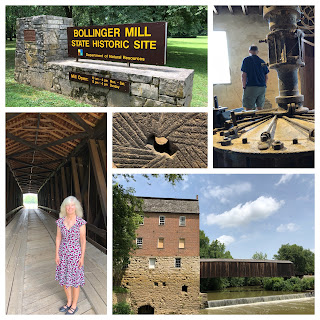
Finally, we squeezed in a stop at the Bollinger Mill Historic Site on our way back from church.

So, there you have it!  Day One with another two days for rest thrown in and we were 186 miles north of Memphis and all the richer for taking the roads less traveled.


Saturday, July 15, 2017

The End of the Trail

Deschutes River State Park

Following the Oregon Trail as Tim and I have done these past few weeks has been an awe-inspiring journey.  It's given us a deep appreciation for the bravery and hardiness of the pioneers who endured the dangers and hardships of the 2,000 mile trail.  Now we are on the final leg of their journey.  Somehow, they had to travel through the gorge of the Columbia River, a wild, raging torrent before today's eleven dams tamed it.  But before they could begin, they had to ford its tributary, the Deschutes River.

As we've come to realize, river crossings were extremely difficult for Oregon Trail emigrants and the Deschutes was no exception.  John McAllister, an emigrant of 1852, warned "danger attends the crossage here...many large rocks and at the same time a very rapid current."  Casualties were common, but Tim and I had no problem, thanks to the safe passage afforded us by Interstate 84, a route that overlays the Oregon Trail.


Nonetheless, while we camped at Deschutes River State Park, it was easy to picture the pioneers' plight.  Listening to the mournful cry of the railroad locomotives whose nearby tracks, too, ran along the old Oregon Trail, I couldn't help but feel that sound was a lament for those souls who died here.

Barlow Cutoff by William Henry Jackson


Rather than hazard a raft trip down the Columbia River as so many other emigrants had done, the Barlow party in 1845 opened the first overland route through the Cascade Mountains, a route that traversed the south side of Mount Hood.  Others followed their way and arrived safely at Oregon City, the historic end of the Oregon Trail.  Tim and I had planned to visit the interpretive center there, but since we've been to similar museums along the way, we decided to give this one a pass.

From 2004-2010, The Freshwater Trust planted 118,000 trees along the Deschutes River to protect native fish and improve water quality.  We appreciated the shade, especially knowing the emigrants were not so fortunate.

Ninety-four percent of those who traveled the Trail reached their destination, but about 20,000 emigrants died on the way.  The fear of death was something they lived with every day.  One out of every 17 people who started the journey died enroute.


But for those emigrant families who survived the treacherous Columbia River, they would find their grueling ordeal at an end.  Three hundred and sixty acres would be their reward when they arrived at the fertile valley of the Willamette River, a basin that today is home to two-thirds of Oregon's population.

"We all felt that now, our journey was ended.  The cattle had been unyoked for the last time; the wagons had been rolled to the last bivouac; the embers of the last campfire had died out; the last word of gossip had been spoken, and now, we are entering a new field with new present experience, and with a new expectancy for the morrow."  Ezra Meeker, 1852

Our reward will be the Dawntreader's safe arrival in Portland.  We have reservations there for four days at the Columbia River RV Park on the northeast side of the city.  Neither Tim nor I have ever visited the Pacific Northwest so we, too, are entering a new field with new expectancies.  We have high hopes.


Thursday, July 13, 2017

Three Island Crossing


When pioneers entered present-day Idaho on the Oregon Trail, many had already traveled more than a thousand miles.


The way was littered with abandoned wagons, dashed dreams and graves.  Still, a great deal of the pioneers' journey remained ahead, and almost immediately, the emigrants faced new obstacles, chief of which was the Snake River.


Near what is now Glenns Ferry, Idaho, the emigrants had a difficult decision to make.  They could attempt the treacherous Three Island Crossing to reach a shorter, easier route north of the Snake River Valley, or they could stay on the rough and dry southern route.  About half of the emigrants decided to cross the swift, deep river here, using the three islands as stepping stones.

Three Island Crossing by William Henry Jackson

"Husband had considerable difficulty crossing the cart.  Both the cart and the mules were capsized in the water and the mules entangled in the harness.  They would have drowned, but for a desperate struggle to get them ashore.  Then after putting two of the strongest horses before the cart and two men swimming behind to steady it, they succeeded in getting it over."  Narcissa Whitman, 1836
Three Island Crossing State Park

Realizing that we needed to push on if we hoped to reach Portland by the middle of July, Tim and I bypassed Fort Hall and several other Oregon Trail milestones in Idaho to spend two nights at Three Island Crossing State Park on the outskirts of Glenns Ferry.

The bottom photos are a replica of the ferry.

Gustavus Glenn in 1869 constructed a ferry here to assist emigrants across the river.  I wonder how much business he had, given that was the year the transcontinental railroad was completed.  But undoubtedly, there were those who couldn't afford a train ticket, plus the freight to ship their possessions west.  I hope they had the money to pay for Glenn's ferry.


We enjoyed our stay at Three Island Crossing State Park.  With over 80 campsites and a small museum, the Oregon Trail Interpretive Center, the park is a green oasis kept that way by the rangers who turn on the sprinkler system with great regularity.  Daily, we dodged the spray as we walked the lower loop and then the upper loop on the cliff overlooking the river.  The contrast between the park and the rough desert terrain next to it is striking.  It's amazing what irrigation can do.

Because we had a rest day here, we drove our car along a portion of the Oregon Trail Back Country Byway.  


Wagon ruts were clearly visible in several places, proof of the pioneers' arduous journey.  


High atop a bluff was the Three Island Overlook, the best view of the three islands.  This must have been the vantage point William Henry Jackson recalled when in later life, he painted his watercolor of Three Island Crossing.


Today, the Snake River Valley is home to more than 50 wineries. The Crossings Winery just beyond the park's boundary, was too close for us to resist.  Tim and I tried several of its award-winning wines before we finally agreed that Passion Peach Sangria was our favorite.

Certainly, that decision was trivial to the life-or-death one the emigrants faced here at Three Island Crossing.


Wednesday, July 12, 2017

Fort Bridger


“I have established a small fort, with a blacksmith shop and a supply of iron in the road of the emigrants on Black Fork of Green River, which promised fairly.”

That was how Jim Bridger, mountain man, described his new venture, a trading post, in a letter to would-be Eastern investors in 1843.  

Fort Bridger by William Henry Jackson

"Fairly?"  Bridger understated his case.  His Eastern friends should have jumped on his business proposal.  Not only did the location promise “fairly,” it became one of the main hubs of westward expansion used by trappers, Indians, emigrants, the U. S. Army, the Pony Express, the Overland Stage and the Union Pacific Railroad.  

It was here that the Oregon Trail turned northwest while the Mormon and the California trails continued on their way. 


Tim and I expected Fort Bridger to be a bigger town.  After all, the fort was Wyoming’s second largest post after Fort Laramie, but the city limit marker noted a population of only 345 people.  Our campground, suitably named Fort Bridger RV Park, and the fort seemed to be the sum total of the town.  That was convenient.  In no time, we'd hooked up our RV, the Dawntreader, to the utilities and meandered over to the fort, all in time for the 2 p.m. tour.


Our tour guide Kim was a fifth generation inhabitant of the area and very knowledgeable about its history.  Of great interest was the Utah War (1857-1858), a conflict whose history was new to me.  Mormon settlers, determined to separate Utah from the United States thereby creating an independent nation where they would be free from religious persecution, blocked the army’s entrance into the Salt Lake Valley.  Scorch and burn was their militia’s strategy to hinder the soldiers as they approached.  They stampeded the army’s horses, set fire to their supply wagons and tried to burn the whole country before them.   Approximately 126 civilians were killed.  In the end, negotiations between the United States and the Mormons resulted in a full pardon, the transfer of governorship from church President Brigham Young to non-Mormon Alfred Cumming, and the peaceful entrance of the U.S. Army into Utah.

A sculpture of Jim Bridger

But I digress--back to the fort whose ownership had fallen into dispute.  Mormons claimed that Jim Bridger sold the flourishing property to them while Bridger argued that it was stolen from him while he was back in Missouri.  Regardless, the post passed to the U.S. Army in 1858 and served as a military outpost until it was abandoned in 1890.


Early the next morning, Tim and I, too, abandoned Fort Bridger.  We had a six-hour trip ahead of us before we would reach our next campground.  Skedaddle, Dawntreader!

Tuesday, July 11, 2017

Sweetwater to South Pass


After crossing the Platte River near Fort Casper, the Oregon Trail pioneers faced the steepest, roughest, driest and most dangerous stretches of the Trail.  Tim and I wondered, too, if the highway we meant to follow would be accessible for our RV, the Dawntreader. 

Notice the cutoffs after South Pass

When I mapped out our route six months ago, I checked Rand McNally’s Motor Carriers’ Road Atlas, an atlas that highlights trucker routes (those with no low-hanging bridges) in yellow, and thought we could go this way.  But now, looking at it again and seeing the towns few and far between, I worried about what might happen if the Dawntreader failed us.  Would we, too, be forced to walk until we could find help?

Luckily, my fears did not faze Tim; he intrepidly turned west and we found the highway to be a good, though lightly travelled, road.


As we drove through the sage-covered territory, my job as navigator was to watch for the marker indicating the turnoff for Independence Rock, so named because trail tradition held that reaching this milestone by the Fourth of July meant the emigrants would arrive safely in Oregon before early blizzards blew. 


I almost missed it.  I wasn’t expecting it to be at a rest stop, but upon reflection, what could be more fitting than for the highway crew to construct a rest stop in the same place the pioneers stopped. 

Dwarfed by the hills to the west of it, Independence Rock looks like a great stone turtle and marks the beginning of the 100-mile climb up the Sweetwater Valley to South Pass.  


Just as they did on Register Cliff, many pioneers left their names carved or painted with tar on the face of Independence Rock, too.

“Thousands of names are engraved and painted by all colors of paint.  I can compare it to nothing so [much] as an irregular loaf of bread raised very light & cracked & creased in all ways.”  Daniel Budd, date unknown
“Names! Names!  Are everywhere upon its surface to be seen.  Names of the young & the old, of the man & his gentle mate, of the learned traveler & the yellow ideaed gold hunter.”  Charles B. Darwin, 1849

Independence Rock by William Henry Jackson

Indeed, I should have recognized the rock from Abigail Scott’s description in her diary, dated June 29, 1852:

“We came twenty miles.  The water (of Sweetwater River) is clear and palatable but is warmer during the day than the water of the Platte.  Independence Rock is an immense mass covering an area of, I think about ten acres, and is about three hundred feet high.  My sisters and I went to the base of the rock with the intention of climbing it but we had only ascended about thirty feet when a heavy hail and windstorm arose obliging us to desist.  Immediately after leaving Independence rock we came in sight of the well-known Devil’s Gate five miles ahead of us…”


Climbing the rock seems to be an irresistible challenge to the young, irrespective of the passage of centuries.  I watched a family of teenagers scale it to the top.  If you look closely at the photo above, you may see them.


Devil’s Gate is clearly visible from the Independence Rock.  It’s a 370-foot high, 1,500-foot long fissure chiseled over the centuries by the Sweetwater River, a river that earned its name for its taste.  French-speaking trappers in the early 1800s called the river “Eau Sucree,” meaning ‘sugar water.’  Emigrants also noted its sweetness, a welcome contrast to the alkaline streams they had encountered to the east.

“Who can gaze on the Sweetwater’s passage through the mountains (called Devil’s Gate) without feelings of the livest emotions?  It is grand, it is sublime!  Fifty feet of a chasm having perpendicular walls three hundred feet high yawning over the gulf below.  He must be brainless that can see this unmoved.  Here memory will dwell.”  John Edwin Banks, 1849

We were unable to get close to Devil’s Gate--it’s now a museum run by the Mormons--but the highway pull-out had placards worth stopping to see.


Our plans called for spending the night at Twin Pines RV Park about seven miles south of Lander.  When we checked in, the owner mentioned several local sites to see.  


We were intrigued by her description of the natural phenomenon within Sinks Canyon State Park.  There the Popo Agie, a rushing river, flows out of the Wind River Mountains and through the canyon.  


Halfway down the canyon, the river abruptly turns into a large limestone cavern, and the crashing water “sinks” into fissures and cracks at the back of the cave.  The river is underground for a quarter mile until it emerges down the canyon in a large calm pool called “The Rise” which is filled with huge trout.  

The Rise

It's hard to see, but those bubbles in the lower left photo are the river as it rises.  The river then continues its course into the valley below.  

Hiking through Sinks Canyon

We found the canyon interesting not only for its geological wonder, but also for its great hiking trails.

One of our challenges on the road, not faced by the pioneers, is finding access to the Internet.  This was especially troublesome at Twin Pines RV Resort where not even our 3G phones could find service in the desolate territory of central Wyoming.  So I typed rough drafts for several blog posts using a word processing program on our laptop; then, we stopped at McDonalds in Lander so I could use their free Internet wifi to upload them.  Problem solved!

Leaving Twin Pines the next morning, we planned to stop at South Pass City, a historical mining district and now a Wyoming State Historic Site.  However, when we turned onto the marked gravel road, we had serious misgivings about the wisdom of this detour.  After traveling a couple miles, Tim determined that this side jaunt was not necessary so he pulled the Dawntreader into a wide spot on the road and we made a very scary U-turn.  


Returning to the highway, we found South Pass (elevation 7,411 feet), a nearly imperceptible hill that straddles the Continental Divide only a few miles ahead.  West of here, the pioneers would have a parting of the ways and head off in differing directions, on differing trails, to their final destination and fortune.

“After getting fairly on the top level of the Pass we halted, to gaze for the last time on the eastern hills and valleys of the Atlantic slope…I was soon brought to ‘a sense of my situation’ by three lusty cheers, given as a sort of adieu to our friends before descending into the valley of the Pacific.”  William Kelly

Not to be outdone, Tim and I echoed their cheers as we, too, drove down the pass.