 |
| The Little Bighorn Battlefield Visitors Center displays this diorama of the battle |
On June 26, 1876, General George Armstrong Custer made his last stand against the Arapaho, Cheyenne and Sioux Indians on a hilltop above the Little Bighorn River.
 |
| General George Armstrong Custer |
His company of 232 soldiers were outmanned ten to one as they fought to the death. Their valor has rightly earned the recognition of military historians and laymen ever since.
 |
| A map of the battle displayed in the visitors' center. |
On our day off from the Habitat for Humanity build in Sheridan, Wyoming, Tim and I drove 70 miles north to the Little Bighorn Battlefield, now a national park in southeast Montana.
 |
| The line of trees is where the Little Bighorn River flows, |
Viewing the topography of the ridge and coulees above the river gave us an experiential perspective of the maneuvers of the doomed 7th Cavalry under Custer's command.
Pressured by gold seekers and pioneer settlers to open up the West, the United States broke one treaty after another with the indigenous tribes who fought back in a series of clashes known as the Sioux Wars. On June 25, 1876, more than 10,000 Indians were camped on the Little Bighorn River. "We must stand together or they will kill us separately," Sitting Bull told his warriors. "These soldiers have come shooting; they want war. All right, we'll give it to them."
Custer divided his regiment into battalions for a three-prong attack on the Indian camp, retaining three companies under his command and placing Major Marcus A. Reno and Captain Frederick W. Benteen in charge of the other two parties. Perhaps Custer planned to move his company behind the battle enjoined by Reno and Benteen in order to take hostage the women, children and elderly of the enemy, a tactic that had served him well in the 1868 Battle of Washita River, near present-day Cheyenne, Oklahoma. But that plan, if indeed that was his objective, went sadly awry. Separated from his subordinates, Custer and his companies were stranded upon a hilltop, surrounded by Indians on all sides.
Slaughtering their horses to form a barricade of their carcasses, Custer and his men tried desperately to hold off the assault until Reno and Benteen could rescue them, but that did not occur.

Just a few miles to the south, Reno was met with heavy resistance from the Indians and ordered a retreat of his men. But Benteen arrived on the scene and the two battalions formed a line on what was later called Reno's Hill. The Indians, learning that their families were threatened, turned their attention towards Custer's party.
Historians theorize that the reason Benteen failed to ride to Custer's relief was due to the deep resentment he felt after Custer abandoned his friend, Major Joel Elliott, during the Battle of Washita. Whatever the truth of that conjecture, Custer and his men were easily overcome by Indian warriors determined to protect their weak.
After listening to the ranger-led program, Tim and I drove 4.5 miles along the ridge, following the approach of Custer's regiment to the battle and using our cell phones to dial the numbers of the park's audio tour. Vivid accounts of the battle by Indians told how Custer's command was surrounded and slain in fierce fighting.
Pressured by gold seekers and pioneer settlers to open up the West, the United States broke one treaty after another with the indigenous tribes who fought back in a series of clashes known as the Sioux Wars. On June 25, 1876, more than 10,000 Indians were camped on the Little Bighorn River. "We must stand together or they will kill us separately," Sitting Bull told his warriors. "These soldiers have come shooting; they want war. All right, we'll give it to them."
 |
| Sitting Bull |
Custer divided his regiment into battalions for a three-prong attack on the Indian camp, retaining three companies under his command and placing Major Marcus A. Reno and Captain Frederick W. Benteen in charge of the other two parties. Perhaps Custer planned to move his company behind the battle enjoined by Reno and Benteen in order to take hostage the women, children and elderly of the enemy, a tactic that had served him well in the 1868 Battle of Washita River, near present-day Cheyenne, Oklahoma. But that plan, if indeed that was his objective, went sadly awry. Separated from his subordinates, Custer and his companies were stranded upon a hilltop, surrounded by Indians on all sides.
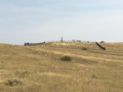 |
| Custer's Last Stand happened on this hilltop. |
Slaughtering their horses to form a barricade of their carcasses, Custer and his men tried desperately to hold off the assault until Reno and Benteen could rescue them, but that did not occur.
Just a few miles to the south, Reno was met with heavy resistance from the Indians and ordered a retreat of his men. But Benteen arrived on the scene and the two battalions formed a line on what was later called Reno's Hill. The Indians, learning that their families were threatened, turned their attention towards Custer's party.
Historians theorize that the reason Benteen failed to ride to Custer's relief was due to the deep resentment he felt after Custer abandoned his friend, Major Joel Elliott, during the Battle of Washita. Whatever the truth of that conjecture, Custer and his men were easily overcome by Indian warriors determined to protect their weak.
After listening to the ranger-led program, Tim and I drove 4.5 miles along the ridge, following the approach of Custer's regiment to the battle and using our cell phones to dial the numbers of the park's audio tour. Vivid accounts of the battle by Indians told how Custer's command was surrounded and slain in fierce fighting.

White tombstones marked the place where the soldiers' bodies were found when troops under the command of Colonel John Gibbon and General Alfred H. Terry arrived June 27th, a day too late to rescue Custer and his men.
While the battle is called Custer's Last Stand, the case could be made that, despite their overwhelming victory, this was also the Indians' last stand. Afterwards, they were hunted mercilessly by the U.S. government and finally herded into reservations, a sorrowful conclusion to the Sioux Wars.
 |
| The Indian Memorial at the battlefield |
While the battle is called Custer's Last Stand, the case could be made that, despite their overwhelming victory, this was also the Indians' last stand. Afterwards, they were hunted mercilessly by the U.S. government and finally herded into reservations, a sorrowful conclusion to the Sioux Wars.


